
Mercator Ocean International offers state-of-the-art expertise and services for ocean analysis and forecasting. Recently, it developed a high-resolution regional system covering the Caribbean, designed to improve the forecasting of Sargassum seaweed beachings for the French government.
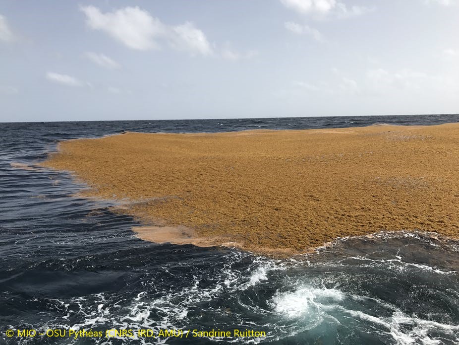
The overabundance and beaching of this seaweed, particularly in the last decade on the coasts of the Caribbean, Central America and Brazil, is a real threat, causing major socio-economic, ecological and health problems. Since the problem began to surge about ten years ago, large deposits of sargassum invade popular beaches, harbours and bays, every season. They pose a variety of issues, including prevent navigation, disrupting habitats, tourism and local fishing, and once beached, they give off a toxic, noxious gas (with hydrogen sulfide and ammonia) causing further public health concerns.
The French government commissions help to track and predict sargassum blooms.
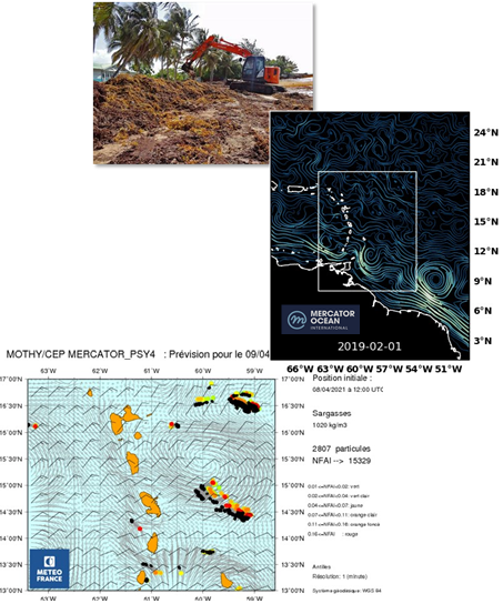
In the French islands of Martinique and Guadeloupe, France experiences large amounts of sargassum coming to shore, impacting local ecosystems, tourism, and local economies. Météo France, the French national meteorological service, has a mandate to monitor pollution drift in these areas. Mercator Ocean International (MOi) supports Météo France and provides a global forecast model and a new high resolution regional model to drive the fit-for-purpose Météo France pollution model called MOTHY. Météo France is also mandated to respond to oil spills and pollution and depend on the same model.
Within the framework of an 18-month agreement signed on 23 November 2020 with the French Ministry of Ecological Transition (MTE), Mercator Ocean International provides Météo France with reliable and accurate subsurface current data for the Caribbean arc region, in order to improve Sargassum drift forecasts and, in particular, to better anticipate mass stranding of these algae on the coasts of Guadeloupe and Martinique.
Using these models and information, Météo France delivers a forecast bulletin to the local authorities of Guadeloupe and Martinique. This allows authorities to be alerted and to anticipate the risks associated with the massive arrival of algae. MOi recently developed the ARCAN36 model that will improve of the drift forecasts of the Sargassum rafts, provided through this bulletin.
What is sargassum?
The growth and drift of Sargassum seaweed is a natural phenomenon, though it can be exacerbated by human activities. Discovered by the great seafarers and explorers of the 15th century, these algae were mainly concentrated in the so-called Sargasso Sea located in the north-western part of the tropical Atlantic and north of the Antilles. However, since 2010, large quantities of Sargassum have been observed from the West African coast to the Gulf of Mexico: this is known as the “Great Sargassum Belt” (“The Great Atlantic Sargassum Belt ”, Wang et al., 2019).
Why have large amounts of sargassum been washing to shore since 2010?
Several hypotheses are possible as to why sargassum has been increasingly washing to shore including:
- An increase nutrients arriving from the Amazon as a result of deforestation and intensification of agriculture in the Amazon, however this possibility has many uncertainties (Jouanno et al., 2021);
- Warming of the tropical Atlantic;
- Changes in hydrodynamic conditions.
None of these hypotheses have been fully explored and confirmed. This is probably because the formation and distribution of sargassum in the Caribbean are the result of complex biological and hydrodynamic processes that are still not fully understood:
- Few studies have been carried out on the physiology of these algae and their response to the environment.
- Waves, wind and currents directly affect the drift of sargassum rafts (large clusters of the seaweed that can sometimes stretch for miles). The extent of the rafts, their shape and thickness (up to 10m) also play a role in their drift. Drift models will need to take these aspects into account as much as possible.
- Sargassum tends to line up with the wind in the form of rafts that can span 10 to100 km long and 1 to 2 km wide. Improving our knowledge of aggregation processes, and taking them into account in numerical models will allow us to obtain better predictions of algal drift.
Prediction of sargassum surges is increasing needed by local and national authorities in order to react to the consequences. With changing global conditions, sargassum “what if scenarios” could be tested in a digital environment. For example, Mercator Ocean could run on demand for the French government such scenarios in a the Digital Twin of the Ocean (DTO). This digital duplication of the ocean is a valuable testing ground where sargassum models could in integrated, allowing French authorities, for example to plan in advance and design data-driven mitigation strategies.
On the agenda of international and national bodies
UNESCO’s Intergovernmental Oceanographic Commission (IOC-UNESCO) for the Caribbean and Surrounding Regions (IOCARIBE), its regional alliance with GOOS (IOCARIBE-GOOS), and GEO Blue Planet GEO are working with partner organisations and stakeholders to develop a multi-hazard information and warning system focusing, initially on oil slick and sargassum drifts. MOi hosts the European GEO Blue Planet Secretariat, leading the GEO Sargassum Working Group.
How the model works
One way of achieving better drift prediction scores for sargassum rafts is to improve the drift models by taking into account certain hydrodynamic characteristics.
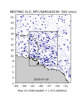
MOi has been supplying Météo France with subsurface currents from the 1/12° global model (GLO12), to force the MOTHY drift model for sargassum monitoring. This allows the model to obtain short-term forecasts (typically 10 days in the future) of algal drift over the West Indies and French Guyana. Forcing MOTHY with higher resolution subsurface currents would improve these forecasts.
Within the convention with the MTE, MOi is developing a 1/36° regional model of the Caribbean Arc, ARCAN36. This system is tidally forced and its low frequency and large scale phenomena are solved by GLO12 at the boundaries. GLO12 assimilates satellite and in situ observations. ( this is a so-called Spectral Nudging method)
Sylvain CAILLEAU, Oceanographer at MOi, explains: “The higher resolution regional configuration called ARCAN36, first developed, tested and validated in Research&Development mode, is then integrated into the operational chain to produce 10-day current forecasts for Météo France. The results obtained by ARCAN36 and GLO12 on the hydrodynamic of the Caribbean Arc region are compared with observed data (mainly from the Copernicus Marine Service). Higher-resolution current forcing are beneficial to Météo France’ sargassum drift forecasts.” The MOi team working on the ARCAN36 model include Sylvain Cailleau, Laurent Bessieres, Guillaume Reffray and Jean-Michel Lellouche.
This work allows MOi to test and improve its internal capacity to quickly and efficiently set up a high resolution regional operational system for a given region and for a particular application and need. The Validation Toolkit developed allows for the development of diagnostic tools, the recovery and adaptation of existing tools, all integrated into a regional validation toolbox documented and hosted in gitlab, and accessible to all at MOi.
Through this project, MOi’s objective is to be able to easily deploy and validate this type of system anywhere in the global ocean and for many other applications.
References
MOi partnership with the PREVIMAR team of Météo-France (interactions with Pierre Daniel and Denis Paradis).
MOi partnership in the FORESEA project (interaction with Julien Jouanno and Léo Berline).
Jouanno, J., Moquet, J. S., Berline, L., Radenac, M. H., Santini, W., Changeux, T., Thibaut, T., Podlejski, W., Menard, F., Martínez, J.M., Aumont, O., Sheinbaum, J., Filizola, N., and N’Kaya, G. D. M.: Evolution of the riverine nutrient export to the Tropical Atlantic over the last 15 years: is there a link with Sargassum proliferation?, Environ. Res. Lett., 16, 034042, https://doi.org/10.1088/1748-9326/abe11a, 2021.
Wang, M., Hu, C., Barnes, B. B., Mitchum, G., Lapointe, B., and Montoya, J. P.: The great Atlantic Sargassum belt, Science, 365, 83–87, 2019.