Ocean Temperature Bulletin
October 2026

Mercator Ocean International (MOi) oceanographers examine marine heatwaves across the global ocean. They analyse a variety of datasets from observation analyses
(satellite sea surface temperature maps) to model analyses
(assimilating satellite and in situ observations) and model forecasts.¹

All images in this article can be used freely and should be credited with the following information :
Image source: European Union, Copernicus Marine Service Data 2025 © Mercator Ocean .

Key takeaway

  • Global (between 60°S and 60°N) sea surface temperatures reached a record high for October 2026, with an average sea surface temperature of 21.01 ± 0.08°C, surpassing the previous October record set in 2023.
  • 75% of the global ocean showed above average mean SSTs in October 2026, with the warmest regions for an October month registered in the Tropical Pacific, the subtropical Atlantic and the northern Indian Ocean.
  • El Niño continued to strengthen, driving exceptionally warm conditions across the tropical Pacific, with some coastal areas of South America experiencing temperatures more than 6°C above average.
  • Marine heatwaves affected 42% of the global ocean, making October 2026 the most extreme October on record for ocean heat stress.

sea Surface Temperature

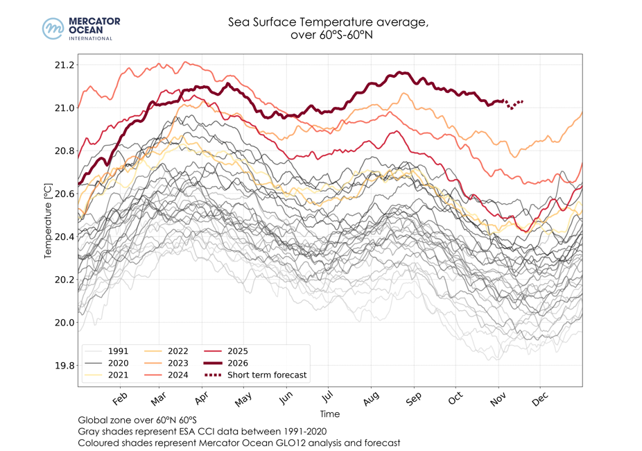
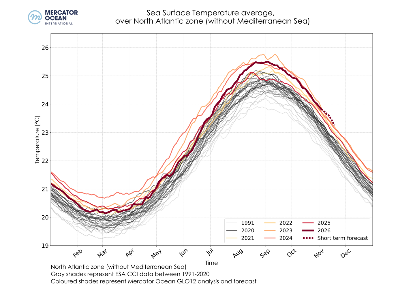
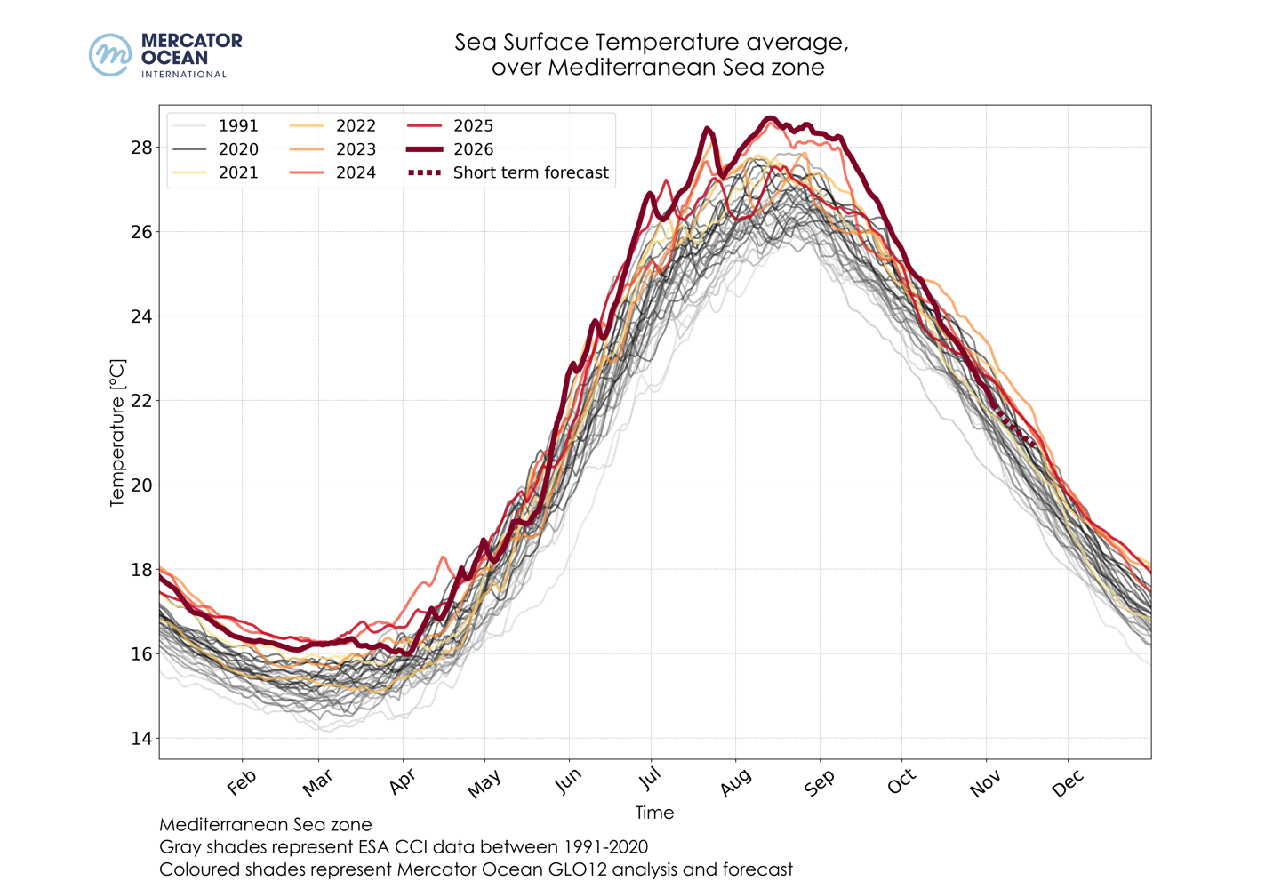
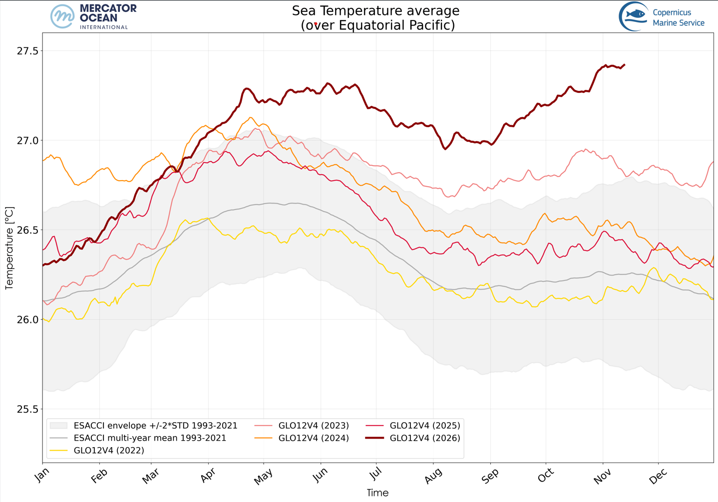
Daily sea surface temperatures averaged for the global ocean (top), the North Atlantic Ocean Mediterranean Sea (left) in the Mediterranean Sea (middle) and in the Equatorial Pacific (30°S-30°N) between 1991-2020 using ESA’s Climate Change Initiative (grey shades), and between 2021-2026 (coloured shades) using Mercator Ocean International’s GLO12 analysis and forecast. Credit: European Union, Copernicus Marine Service/Mercator Ocean International


  • October 2026, at global level (between 60°S and 60°N), was the warmest October on record, with a mean Sea Surface Temperature (SST) of 21.01 ± 0.08°C, significantly exceeding the previous record set in 2023 (20.83±0.06°C). 
  • In the Mediterranean Sea, October 2026 was the 5th warmest October on record, with a mean SST of 23.87 ± 0.23°C , behind 2014, 2019 (23.96 ± 0.13 °C), 2012 (23.99 ± 0.30 °C) and October 2023 (24.44 ± 0.08 °C).
  • In the North Atlantic (between 0°N and 60°N), October 2026 was the 3rd warmest October month with a mean SST of 24.48 ± 0.05°C, behind October 2024 (24.50 ± 0.06°C) and 2023 (24.63 ± 0.04°C).  


Sea surface temperature anomalies

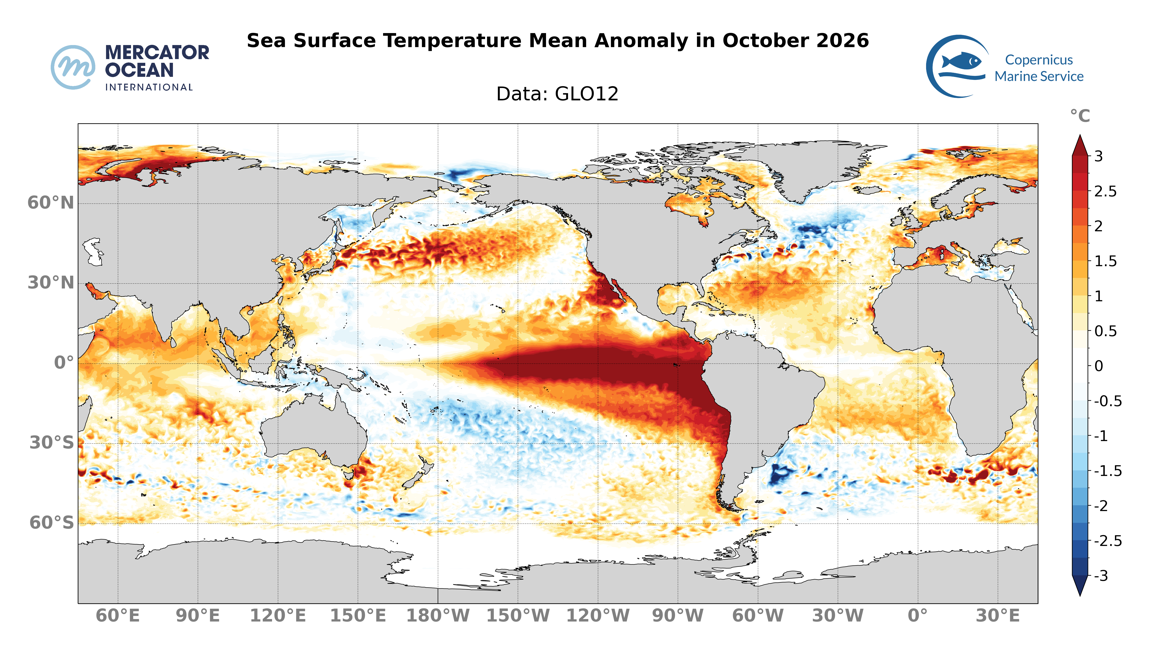
Mean sea surface temperature anomaly in the global ocean for October 2026 relative to a 30-year climatology (1993-2022), calculated using daily data from Mercator Ocean International’s GLO12 analysis and forecasting system for 2026 and from the GLORYS12 reanalysis for the climatological mean. Credit: European Union, Copernicus Marine Service/Mercator Ocean International


75% of the global ocean (between 60°S and 60°N) showed above average mean SSTs in October 2026, and 31% of the ocean was above average by at least 1°C.
  • 68% of the Mediterranean Sea showed above-average SSTs, with stronger SST anomalies in the western part, reaching more than 2.5-3°C in the Adriatic Sea and along the French, Italian and Spanish coast. 36% of the Mediterranean Sea is above average by at least 1°C 
  • The North Pacific Ocean has seen sea surface temperatures (SSTs) that were mostly above average, covering a band in the Sea of Japan and in the central North Pacific, reaching or even exceeding 3°C above average, mainly between 150°E and 180°W. In the subtropical region, between 160°E and Mexico and along the coasts, sea surface temperatures (SSTs) reached values between 2 and 3°C above average, even exceeding 5°C along the coasts, with highest anomalies around California. SSTs across the entire Chinese Sea and South-East Asia (particularly to the north of the island of Borneo) are between 1 and 2°C above average. In the South Pacific, SSTs locally reach 2.5 °C above average in south-eastern Australia. Along a diagonal stretching from Papua New Guinea to the southern part of the basin, around 120°W, the basin is covered with SSTs between 0.5 and 2°C below average.
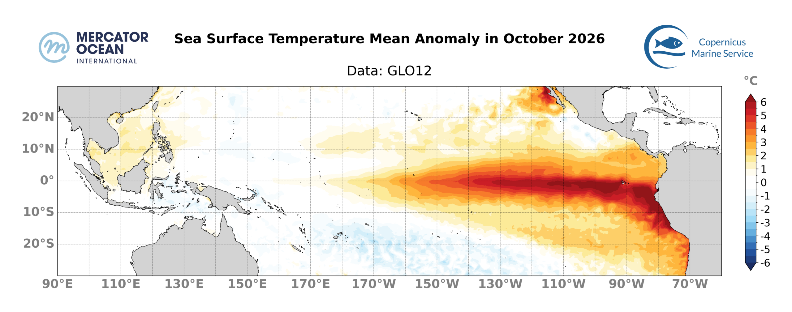
Mean SST anomaly in the Equatorial Pacific (30°S-30°N) for October 2026 relative to a 30-year climatology (1993-2022). It is calculated using daily data from Mercator Ocean International’s GLO12 analysis and forecasting system for 2026 and from the GLORYS12 reanalysis for the climatological mean. Credit: European Union, Copernicus Marine Service/Mercator Ocean International


  • 70% of the Equatorial Pacific showed above-average SSTs, with 43% exceeding 1°C or more. The entire band between 180°W and the coast of South America is characterised by high SSTs, with large areas exceeding 3°C above average. Near the coast, these above-average sea surface temperatures extend along the entire west coast of Central and South America, with values exceeding 4°C and potentially rising above 6°C, particularly along the Peruvian coast. 22% of the Equatorial Pacific showed SSTs above average by at least 2°C, in September this surface value was 17% – this development indicates that the El Niño phenomenon continues to intensify.
  • 83% of the North Atlantic show above average mean SST, with 24% above average by at least 1°C. A broad band of above-average sea surface temperatures (SST) extends across the basin, from the Gulf of Mexico to the west and north of Europe, where SSTs reached between 1 and 2 °C above average and have locally reached 2.5 °C. Off the coast of Guinea, sea surface temperatures are exceeding 2°C above average along the coast. Mid-latitudes showed below-average SSTs, between the Canadian coast and 30°W, with SSTs locally as low as 3°C below average (“cold blob” region)
  • The South Atlantic showed above-average SSTs across the entire width of the basin, between Brazil and the South African coast. SSTs reached more than 3°C above average off the coast of South Africa 
  • In the Indian Ocean, SSTs are between 1 and 2°C above average across most of the basin (above 30°S), including the Arabian Sea and the Bay of Bengal. Locally, these temperatures are reaching 2.5°C above average, particularly off the coast of Somalia, in the Persian Gulf and around 20°S, 90°E. 


Ranking October 2026 record SST

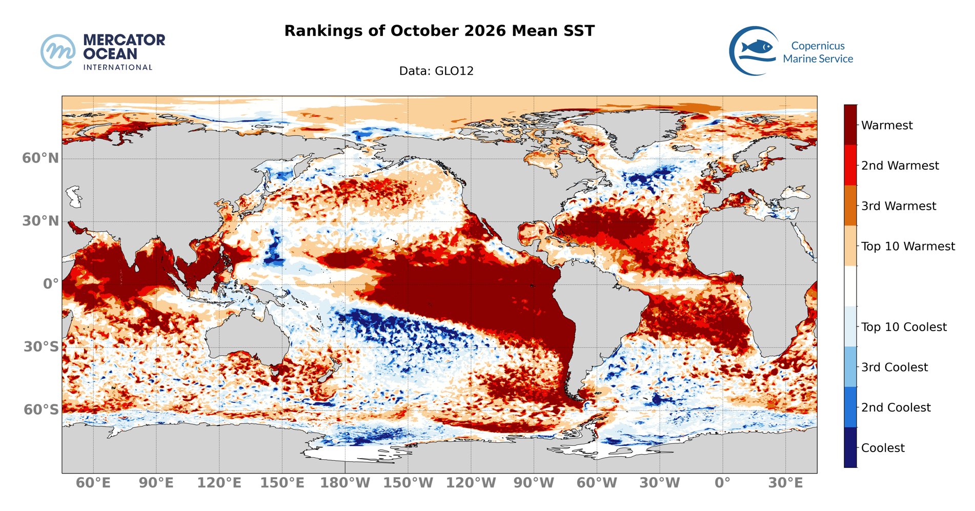
Ranking of monthly October 2026 SSTs against previous October months of the historical period (since 1993). Credit: European Union, Copernicus Marine Service/Mercator Ocean International


  • Around 24% of the global ocean (between 60°S and 60°N) ranked as the warmest October month on record, with the tropical Pacific, the subtropical Atlantic and the northern Indian Ocean being the regions most affected. Regions such as the subtropical north of the Pacific, the mid-latitudes of the North Pacific and the western Europe are also characterised by vast areas where October 2026 was the warmest on record. 43% of the Global ocean was among the four warmest Octobers on record.
  • 14% of the Mediterranean Sea ranked as the warmest October month on record and 32% of its area was among the four warmest Octobers on record, mainly in the western part. 19% of the North Atlantic ranked as the warmest October Month and 48% among the four warmest.
  • In the Equatorial Pacific, 37% of its area was ranked as the warmest October month on record, 49% among the four warmest. In addition to the El Niño component in the eastern equatorial Pacific, records for average SSTs were broken in the South-East Asian basins 

Ongoing Marine Heatwaves

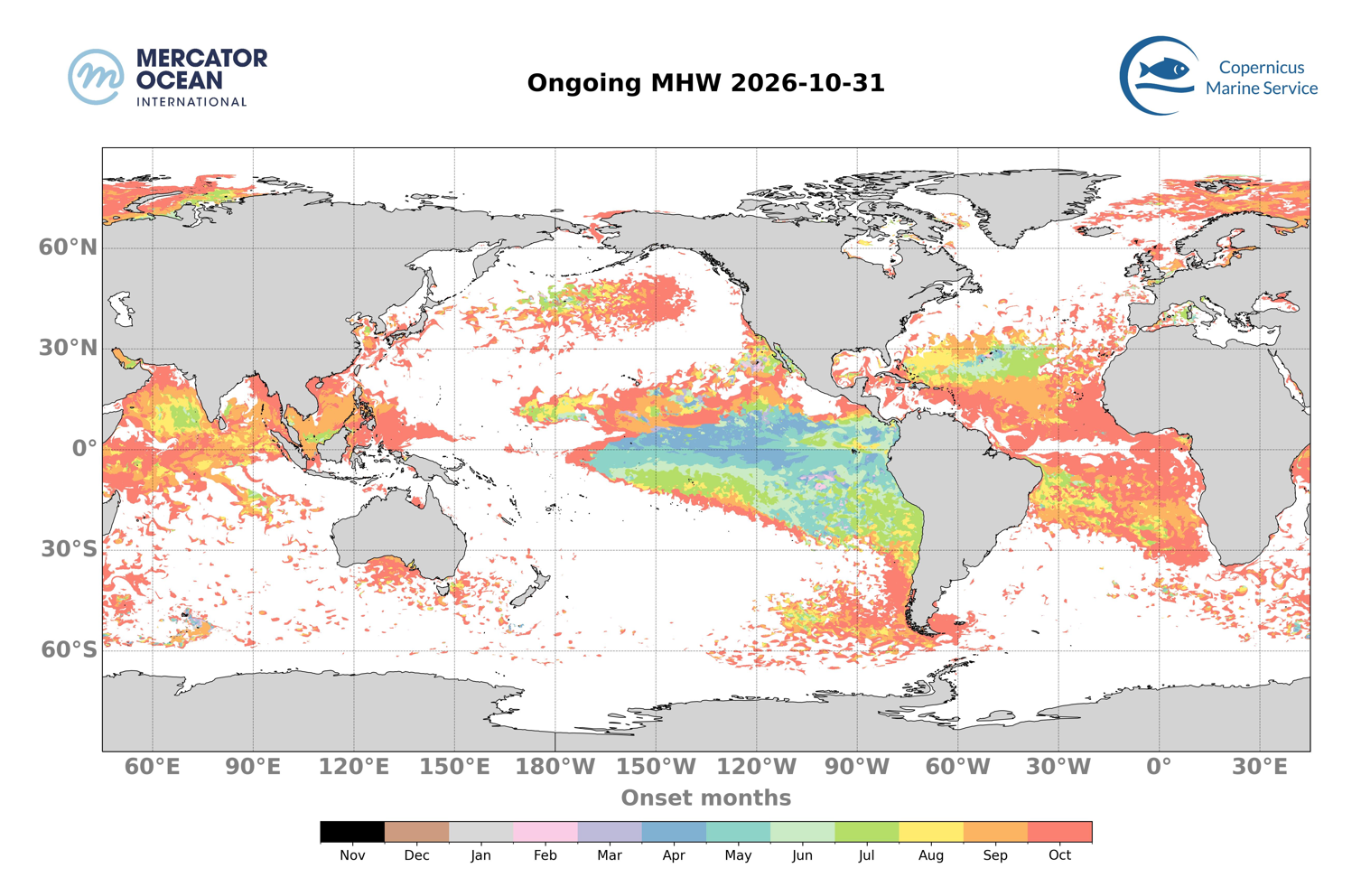
Month of onset for the ongoing MHWs on the 31st of October 2026. The colours indicate the month during which the MHW started. For instance, ocean pixels in red correspond to an MHW that developed during October 2026 and are less than one month old, in orange MHW between 1 and 2 months old, etc. Credit: European Union, Copernicus Marine Service/Mercator Ocean International
  • On the 31st of October, 42% of the global ocean (between 60°S and 60°N) was affected by MHWs.  
  • Almost half of these MHWs developed recently, with close to 20% of the global Ocean (between 60°S and 60°N) affected by MHWs less than 1 month old and 11% by events between 1 and 3 month old. 11% of the global Ocean is affected by events more than 3 month old. These persistent events are mainly found in the Equatorial Pacific, in connection with the ongoing El Niño episode 
  • Oldest MHW are developed since January in the south of California.   
  • In the subtropical Atlantic MHWs have been locally present for 5 to 7 months


Total Surface Marine Heatwaves


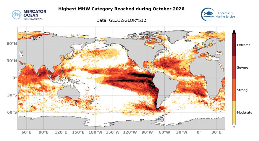
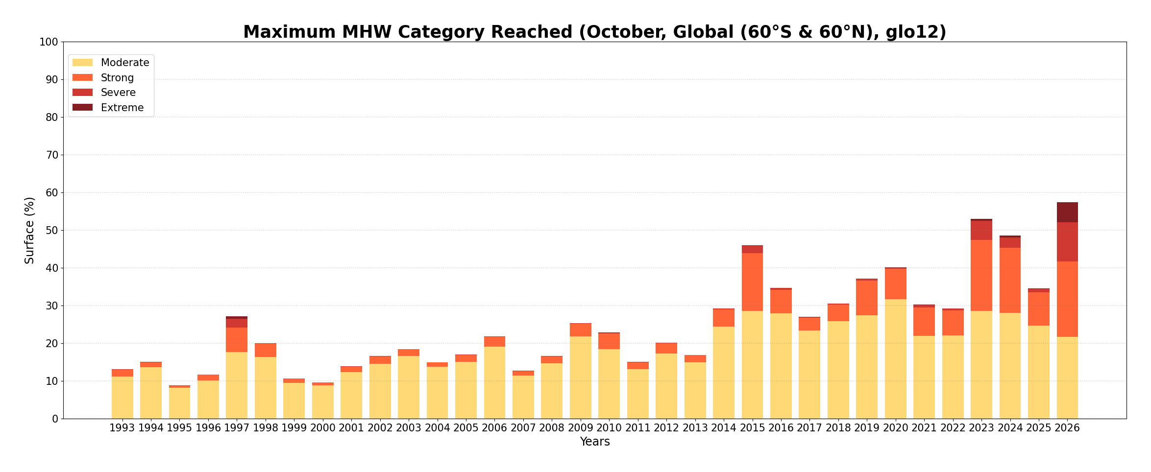
Top: Highest marine heatwave category reached in September 2026. Below: Maximum surface (%) occupied by MHW by each category (moderate, strong, severe and extreme) since 1993. Credit: European Union, Copernicus Marine Service/Mercator Ocean International


In October 2026, the total surface area of MHW (black line) slowly increased from 41% to 42% of the global ocean (between 60°S and 60°N. The majority of MHWs events were of moderate categories (between 20-23% of the global ocean) and strong category that reached around 12-13% of the global ocean. Severe MHWs were between 4% and more than 5% of the global ocean during October 2026. There has been a decline in the moderate categories, which have been replaced by higher MHW categories 

Despite slower growth this month, MHW’s surface has been steadily increasing for nearly a year. 
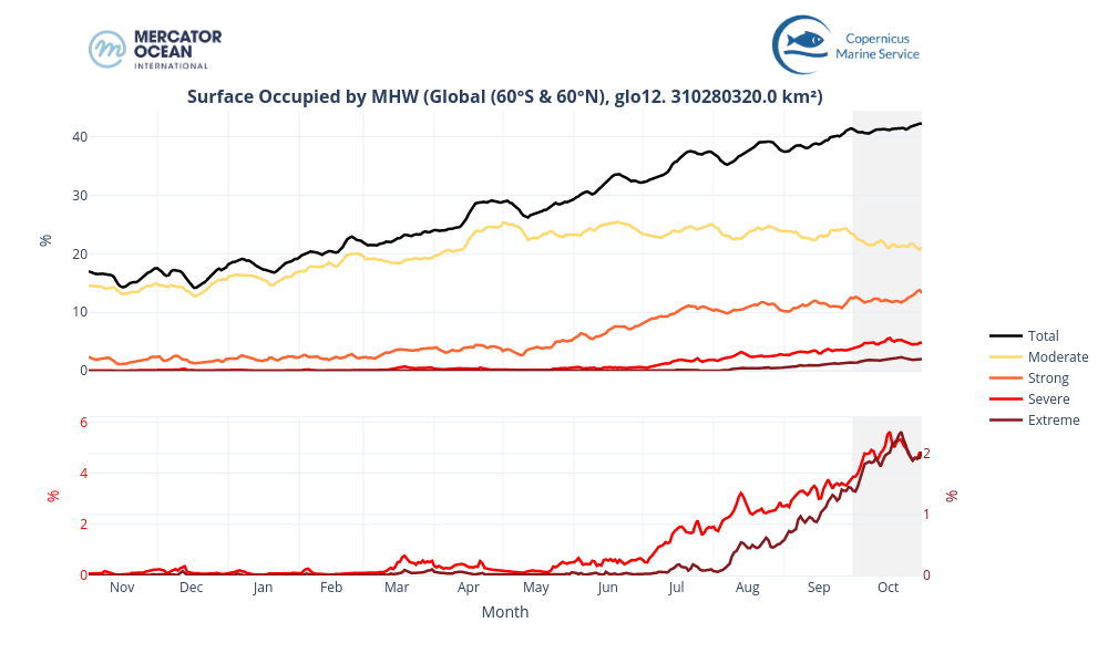
 

Surface occupied by MHWs in the global ocean (between 60°S and 60°N) between November 2025 and October 2026 based on daily monitoring. The black solid line represents the total surface of MHW, while the coloured lines represent the surface of each MHW category. The grey background highlights the month of October 2026. Credit: European Union, Copernicus Marine Service/Mercator Ocean International


Total Number Marine Heatwaves

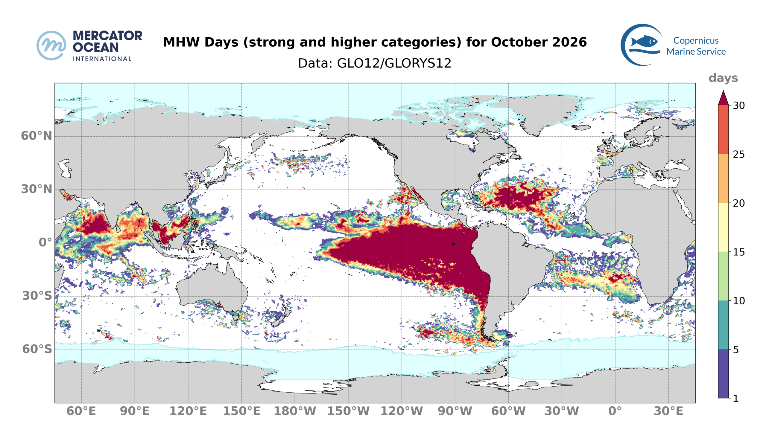
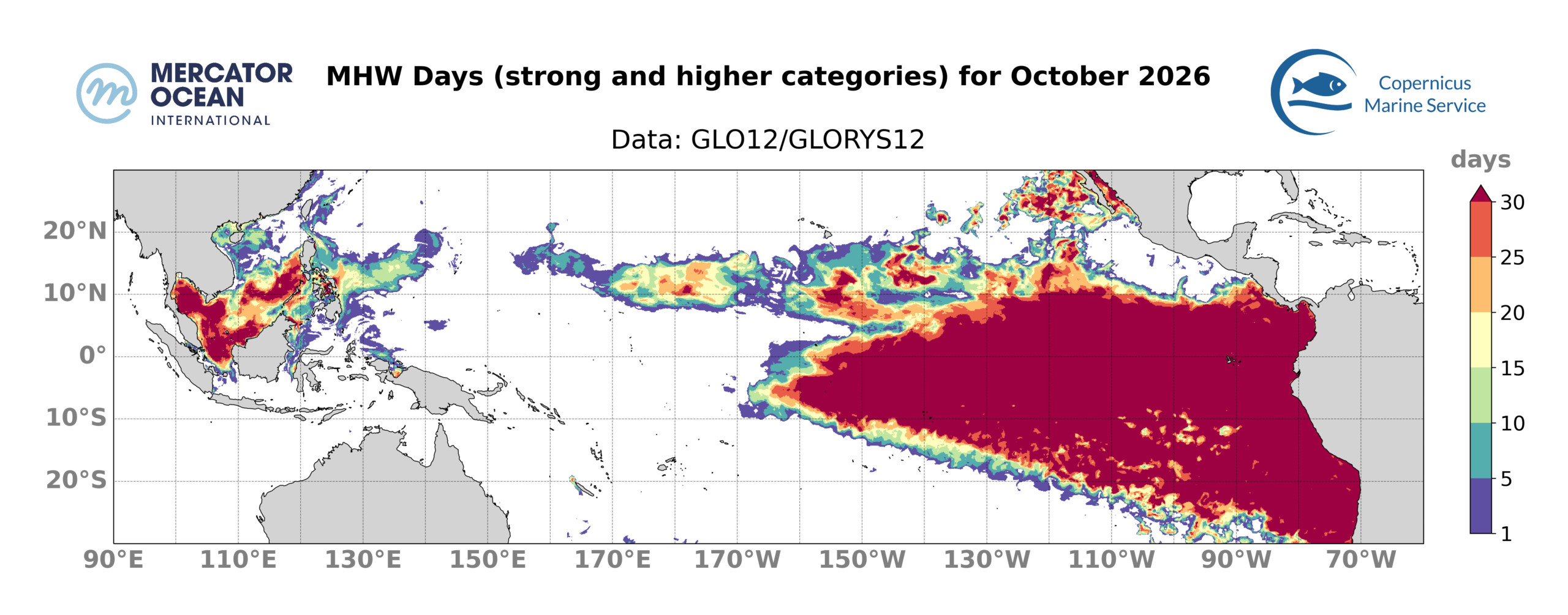
October 2026 MHW days of strong and higher category. Number of days during which a MHW of category strong, severe or extreme occurred in October 2026. Blank areas mean that no MHW of strong or higher category happened during the month. Blue shaded areas in the polar regions represent the sea ice maximum from the climatological period (1993-2022). Monitoring SST extremes with the MHW categorization approach as used here is not best suited for such regions. Credit: European Union, Copernicus Marine Service/Mercator Ocean International


  • 36% of the surface of the ocean was impacted by strong-or-higher MHW conditions for at least 1 day during October 2026. This is the 1st widest extent of the last 34 years, far exceeding the previous record set in 2023 (24 %). The central Pacific, the subtropical Atlantic and the Indian ocean are the most affected, with areas where MHWs persisted the entire month (Figure 8). 10% of the surface of the ocean was impacted by strong-or-higher MHW conditions the entire month. This is mainly linked to the current El Niño event, with persistent MHW in the Equatorial Pacific. 
  • Regionally, 41% of the North Atlantic (between 0°N and 60°N) was impacted by strong, or higher, MHW conditions for at least 1 day. This corresponds to the 2nd largest extent of the last 34 years for a October month, behind 2023 (53%). The band between 15°N and 35°N are the regions that have been affected by strong MHWs or higher for the longest period of time 
  • For the Mediterranean Sea, 22% of the basin was affected by strong-or-higher MHW conditions for at least 1 day, which is the 2nd largest extent of the last 34 years for a October month, behind October 2023 with 28%.  
  • For the Equatorial Pacific, 46% of the region was affected by strong-or-higher MHW conditions for at least 1 day, which is the 1st widest extent, far ahead of 2015 (26%). 24% of the surface of the Equatorial Pacific Ocean was impacted by strong-or-higher MHW conditions the entire month. It is a record, well ahead of 1997 (more than 8%), which was also a year with an intense El Niño event 


Statistics

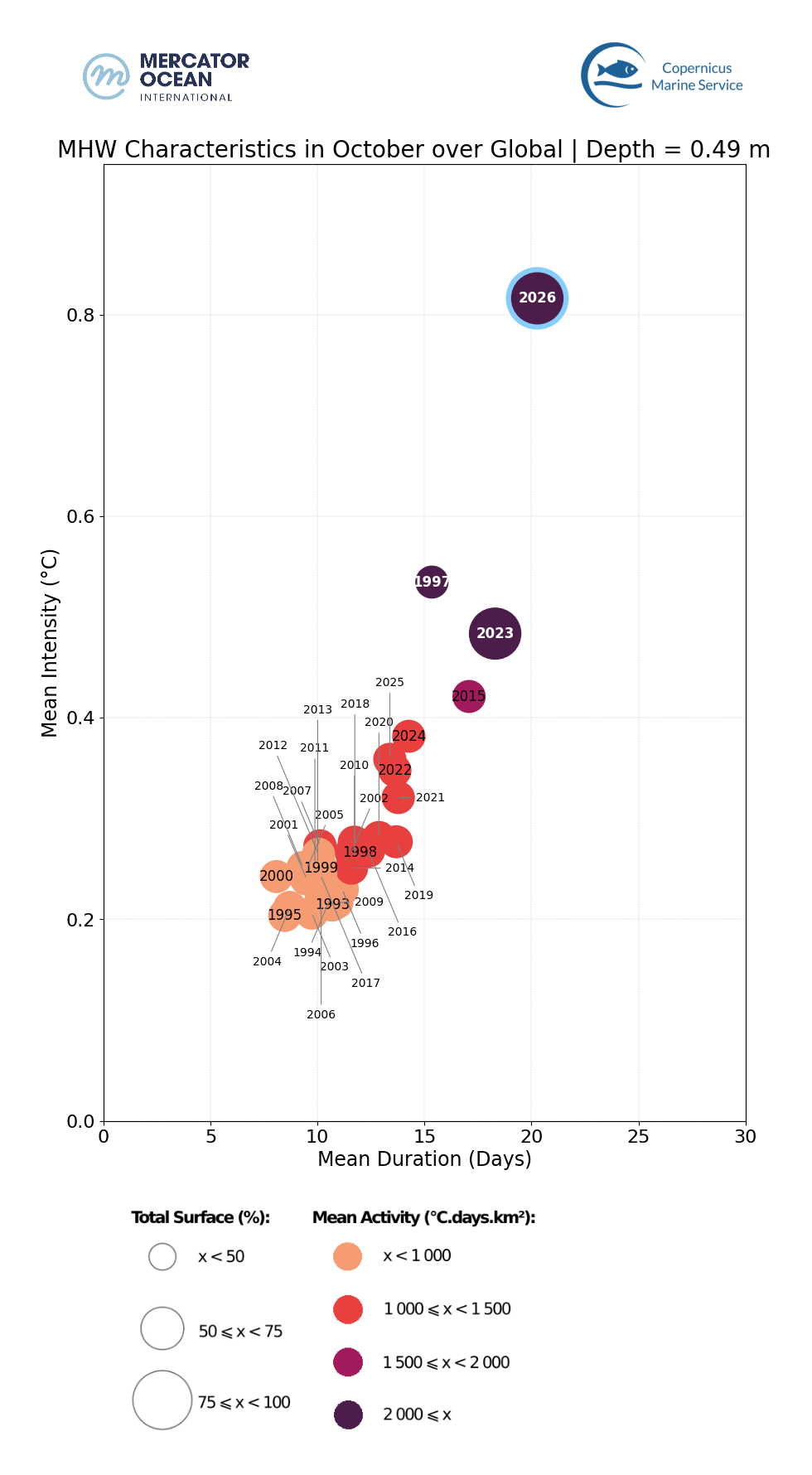
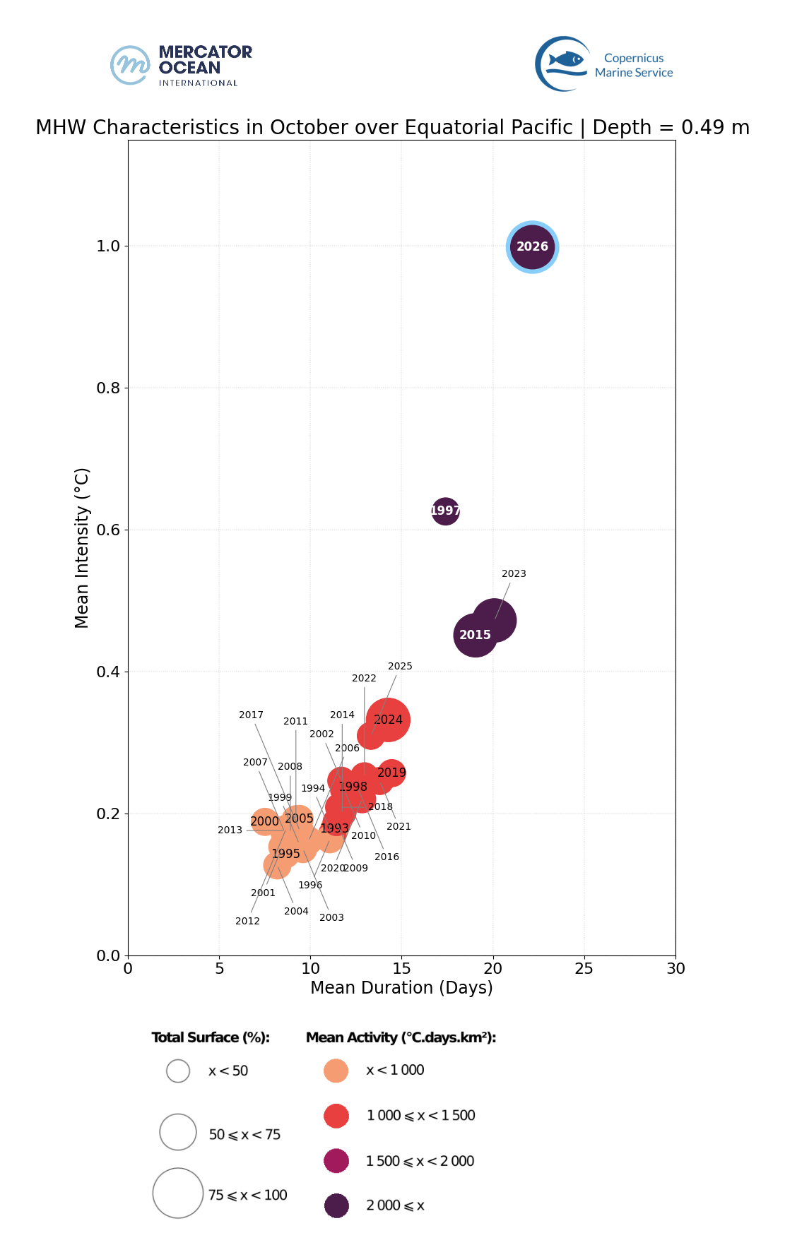
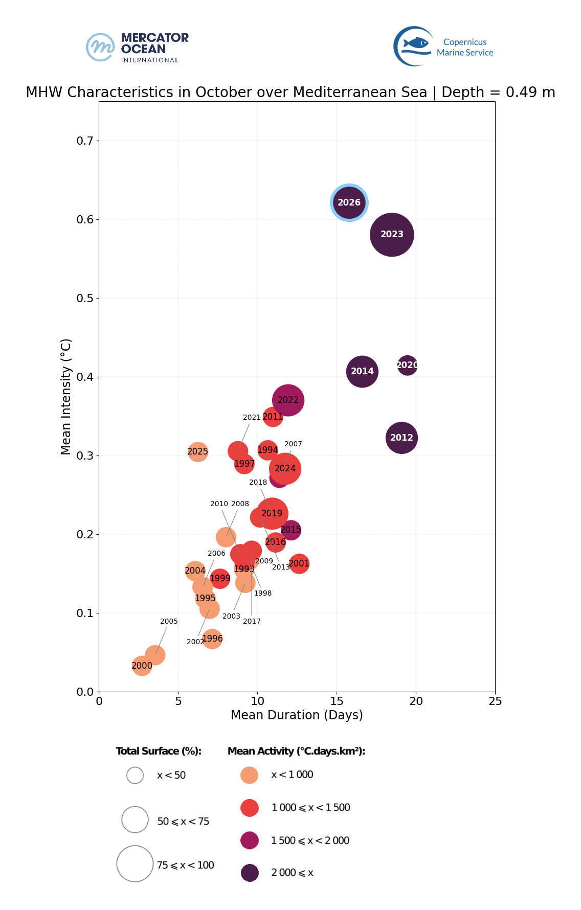
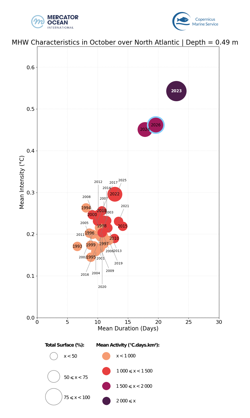
Marine heatwave statistics ( intensity, duration, activity and surface)

  • October 2026 was the most extreme October regarding MHWs, in the global ocean. It was well ahead of 2023 and 1997 considering intensity levels.
  • In the Mediterranean Sea, October 2026 was the most intense October, ahead 2023, and the 5th most extreme October in terms of duration, behind 2014, 2023, 2012 and 2020.
  • In the North Atlantic, October 2026 was the 2nd most extreme October month in terms of MHW from the last 34 years, behind 2023.
  • In the Equatorial Pacific, October 2026 was the most extreme October in terms of MHW intensity, far ahead 1993 and 2023. It was also the most extreme October in terms of MHW duration, but close to October 2023 (previous .  This highlights the extreme nature of the current El Niño event

About the Bulletin

Mercator Ocean International publishes a monthly sea surface temperature bulletin reporting on mean temperature and marine heatwave conditions for the month or season just passed. It includes:

  • Regions where MHWs are present and the time these events started,
  • Timeseries showing the total surface occupied by MHWs globally and for the European region,
  • The total number of days of exposure to MHW during the month (including only strong and higher intensity categories).

Data sets and products

Sea Surface Temperature

The results are obtained using the Copernicus Marine Service global analysis and forecasting system together with observation-based products.

  • GLOBAL_ANALYSISFORECAST_PHY_001_024 Global Ocean Physics Analysis and Forecast sea surface temperature. U. Copernicus Marine Service Information (CMEMS). Marine Data Store (MDS). DOI: https://doi.org/10.48670/moi-00016
  • ESA SST CCI reprocessed sea surface temperature analyses. E.U. Copernicus Marine Service Information (CMEMS). Marine Data Store (MDS). DOI: https://doi.org/10.48670/moi-00169
  • NOAA OI SST V2 High Resolution Dataset data provided by the NOAA PSL, Boulder, Colorado, USA, from their website at https://psl.noaa.gov, Huang, B., C. Liu, V. Banzon, E. Freeman, G. Graham, B. Hankins, T. Smith, and H.-M. Zhang, 2021: Improvements of the Daily Optimum Interpolation Sea Surface Temperature (DOISST) Version 2.1, Journal of Climate, 34, 2923-2939. doi: 10.1175/JCLI-D-20-0166.1
  • Global Ocean OSTIA Sea Surface Temperature and Sea Ice Analysis. E.U. Copernicus Marine Service Information (CMEMS). Marine Data Store (MDS). DOI: https://doi.org/10.48670/moi-00165
  • ODYSSEA Global Sea Surface Temperature Gridded Level 4 Daily Multi-Sensor Observations. E.U. Copernicus Marine Service Information (CMEMS). Marine Data Store (MDS). DOI: https://doi.org/10.48670/moi-00016

Notes: The global analysis system was used to study the ocean surface temperature from 2021 and 2025. To study surface temperature for previous years (1991 to 2020), it was used the ESA CCI data. The other observation-based sea surface temperature products (OSTIA, OI SST and Odyssea) were used for calculating monthly mean and uncertainty values for October 2026.

 Marine Heatwaves

The results are obtained using the Copernicus Marine Service global systems including the analysis and forecasting system together with the reanalysis product.

  • GLOBAL_ANALYSISFORECAST_PHY_001_024 Global Ocean Physics Analysis and Forecast sea surface temperature. U. Copernicus Marine Service Information (CMEMS). Marine Data Store (MDS). DOI: https://doi.org/10.48670/moi-00016
  • GLOBAL_MULTIYEAR_PHY_001_030 Global Ocean Physics Reanalysis sea surface temperature. U. Copernicus Marine Service Information (CMEMS). Marine Data Store (MDS). DOI: https://doi.org/10.48670/moi-00021

Notes: The global analysis system was used to study MHWs for 2024 and 2025. To study MHWs for previous June, July and August months (1993 to 2025), it was used the reanalysis system. The reanalysis product was used for generating a daily climatology using the 30-year period from 1993 to 2022.