Ocean Monitoring & Forecasting
Home ⟩ Ocean Data ⟩ Ocean Monitoring & Forecasting
As a global leader in operational oceanography, Mercator Ocean International empowers informed decision-making through the Copernicus Marine Service and other international initiatives. We provide essential Ocean data and forecasting tools for scientists, policymakers, and buinesses, supporting sustainable Ocean management and a resilient blue economy.
The Ocean shapes our weather, climate, and biodiversity while providing essential resources. Monitoring and predicting its behavior is key to marine safety, accurate forecasts, ecosystem protection, sustainable resource use, and reducing disaster risks.
From Observation to a Digital Ocean: a 30-year Journey
Operational oceanography is the science of observing, analyzing, and predicting the Ocean’s state—past, present, and future. Born in 1995 from satellite observations and 3D numerical modeling, this discipline integrates real-time data into complex models, giving rise to a truly digital Ocean.
Today, operational oceanography is a global, collaborative effort underpinning essential services, climate monitoring, disaster response, and the sustainable blue economy. Driven by recent advances in artificial intelligence and advanced computing, our digital Ocean now delivers unprecedented speed and accuracy in forecasts, enabling actionable insights to better protect the Blue, White, and Green Ocean.
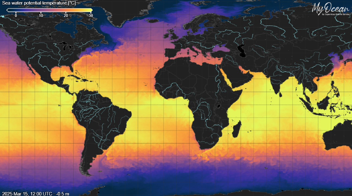
Comprehensive Ocean monitoring and forecasting systems integrate satellite and in-situ data to model the Blue (physical variables), White (Sea Ice variables), and Green (biogeochemical variables) Ocean
The Operational Oceanography Value Chain
The operational oceanography value chain begins with the collection and preparation of marine-relevant input data. These are processed through marine modelling systems and transformed into products such as analyses, reanalyses, forecasts, and indicators, which are then delivered to users and support a wide range of applications.
From observations to users, the value chain includes:
- Observation: Gathering data from satellites, buoys, ships, and underwater vehicles.
- Data Management: Quality control and integration of diverse data streams.
- Modeling and Data Assimilation: Using advanced models and data assimilation to create comprehensive analyses and forecasts.
- Product Generation: Producing past, present, and future Ocean state information, on the surface and at depth.
- Dissemination: Delivering user-friendly data, indicators, and tools to a global audience.
- User Engagement: Incorporating feedback to continually improve services.
Operational oceanography value chain—from satellite and in-situ observations, through 3D model simulations and expert analysis, to verified data, indicators, and services delivered to decision-makers worldwide.
Monitoring and Forecasting Systems
Reliable Ocean forecasts result from combining real-time satellite and in-situ observations with advanced numerical models. Numerical models of the Global Ocean and European Seas use data assimilation methods, applying data-driven constraints, to represent interactions of the Ocean with sea ice, the atmosphere, and marine biogeochemistry, and integrating as much observation-based data as possible from in-situ or satellite sources.
Through data assimilation, these observations are integrated into models to create accurate forecasts. Indeed, these numerical models are already prototypes for digital twins of the Ocean. When models diverge from reality, it highlights gaps in our knowledge and guides further research and data collection.
Operational Ocean forecasting supports critical activities such as navigation, disaster response, climate prediction, and marine resource management. Recent advances in machine learning and artificial intelligence are revolutionizing this field by enabling the creation of more sophisticated digital twins—interactive, high-resolution virtual models that mirror real ocean conditions, allowing scientists and decision-makers to simulate and assess the impacts of various actions, such as reducing CO₂ emissions, establishing marine protected areas, or managing fisheries and marine pollution. For a detailed overview of these systems, see the ETOOFS Guide, developed by GOOS, Mercator Ocean International, IOC-UNESCO, and WMO.
Mercator Ocean International: Leading the way
Mercator Ocean is transforming into an intergovernmental organization (IGO) dedicated to digital Ocean systems and services, filling a critical gap in authoritative international leadership. With robust infrastructure like the Copernicus Marine Service and the Digital Ocean Twin, coupled with structured scientific collaboration via the UN Decade of Ocean Science, operational oceanography is reaching maturity.
- Through the Copernicus Marine Service, Mercator Ocean converts satellite observations, in situ observations, 3D model simulations, and expert knowledge into 30 Ocean Variables updated every 2 minutes on a 10 billion grid point digital Ocean,
- The Copernicus Marine Service translates expert knowledge into verified data, indicators, reports, and training sessions. It receives more than 1 million visits each year and has 120,000 registered users who download and use its data and products.
As a future Intergovernmental organization (IGO, it will be dedicated to:
- Describing and forecasting the physical and biogeochemical state of the Ocean globally.
- Providing reliable, science-based knowledge and digital services to coastal states and international organizations.