What is the OceanPrediction Decade
Collaborative Center?
The Decade of Ocean Science for Sustainable Development 2021-2030 is being coordinated by the Intergovernmental Oceanographic Commission of UNESCO (IOC-UNESCO) to promote transformational, large-scale change to advance urgent action on moving from the ‘Ocean we have’ to the ‘Ocean we want’.
The OceanPrediction Decade Collaborative Center (OceanPrediction DCC), hosted by MOi, is a Decade cross-cutting structure that will work at the global scale to develop collaboration between Decade Actions and other key actors related to Ocean prediction (see the section “Ocean Prediction…. what is it and why it is important?”).
Mission
A predicted Ocean based on a shared and coordinated global effort in the framework of the UN Ocean Decade.
Vision
To galvanize and coordinate efforts towards the co-development and integration of worldwide Ocean prediction activities, serving Decade objectives and in close collaboration with the Decade endorsed actions and other stakeholders.
Pierre Bahurel, Director General of Mercator Ocean International, explaining what the OceanPrediction Decade Collaborative Centre is.
Enrique Alvarez, Technical Coordinator of the OceanPrediction DCC at MOi, explains the role of community and the need for a coordinated global technical and organisational structure for Ocean prediction activities.
OPERA
Ocean Prediction Enhancement in Regions of Africa (OPERA) is a five-year (2025–2029), €10 million EU-funded project under the Africa Regional Centres of Excellence programme. It aims to strengthen ocean prediction capabilities across Sub-Saharan Africa at national, regional, and pan-African levels. Mercator Ocean International, through its coordination of the OceanPrediction Decade Collaborative Centre and its African Seas regional team, is responsible for implementing OPERA.
OP4CR
Ocean Prediction for Costa Rica (OP4CR) is a two-year initiative led by Mercator Ocean International and the European Commission to strengthen Costa Rica’s digital ocean capabilities and connect the country to global ocean prediction networks. The project enhances national capacity to access, use, and develop ocean forecasting tools through close collaboration with local institutions, universities, NGOs, and stakeholders.
What are the objectives of the OceanPrediction DCC?
A global community
To provide a backbone collaboration structure and collective voice to the Ocean prediction community, supporting the Decade implementation. This community will be formed by individuals and institutions with a wide range of profiles, including scientists, private companies, policymakers, and users.
A technical infrastructure
To build a global technical and organisational structure, focused co-design with Ocean Decade actions and other relevant actors to develop a new scenario for Ocean forecasting that will be based on interoperability and an architecture to ‘deliver as one’, leveraging the coming innovations derived from the digital twining concept.
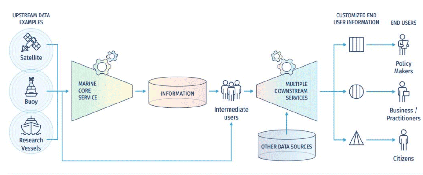
A new scenario for Ocean forecasting
Forecasting Systems have proven to be highly valuable, as they contribute to our understanding of the Ocean and provide priceless information for decision-making. However, they face numerous challenges, in standardisation, interoperability, and integration. As a result, building a forecasting service from scratch, without experienced guidance, remains a huge challenge. When successful, it often produces an isolated service, with limited possibilities of integration into a larger framework.
This situation limits the forecasting services proliferation – especially in less technologically advanced countries, as well as the growth of our Ocean forecasting community and our common shared knowledge.
The OceanPrediction DCC and its associated Decade programmes are working together to change this scenario. We are doing so by defining common architectures and new Tools, Standards and Best Practices to standardise and improve the way we build the Ocean Forecasting value chain, taking advantage of the concept of digital twinning.
What Tools Are Essential for Ocean Forecasting Capacity Development?
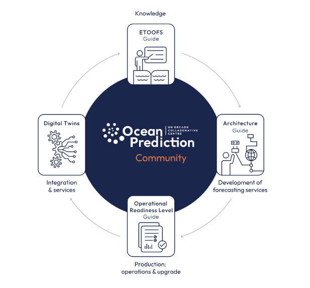
In the field of Ocean forecasting, three essential guides have been developed to support the creation and implementation of effective systems.
The ETOOFS Guide serves as a comprehensive manual, outlining international standards and best practices for establishing Ocean forecasting services, while training and inspiring professionals in the field. The Architecture Guide provides technical specifications and wiring diagrams to help build interoperable Ocean prediction systems, addressing modern technological challenges. Lastly, the Operational Readiness Level (ORL) Guide equips developers with tools to assess the technical aspects of a system, enhancing service qualifications and overall forecasting capabilities. Together, these resources form a robust foundation for developing efficient and integrated Ocean forecasting systems.

PIERRE BAHUREL
DIRECTOR GENERAL
OF MERCATOR OCEAN
INTERNATIONAL
A Decade Collaborative Centre dedicated to ocean prediction
would not only have a coordinating role, bringing together a broad range of user communities to be a part of this incubator and co-design mechanism, but it will also work to deliver. We want to foster an ocean science-to-service approach to develop powerful ocean prediction capacities around the world for a sustainable ocean, giving every citizen on our blue planet the power to understand what is happening or will happen in our ocean, and ultimately to our planet.
VIDAR HELGESEN
SECRETARE EXECUTIF,
COI-UNESCO
The IOC has a unique mandate
it unites our commitment to advancing Ocean knowledge with a bold vision for sustainable Ocean management and an Ocean-literate society. The creation of the OceanPrediction DCC is a prime example of how we’re turning that vision into action. By supporting collaboration and innovation in Ocean forecasting worldwide, it will help ensure the Ocean Decade delivers tangible, science-based solutions.

Atlas
Explore the ocean forecasting world, its members, systems & services

Resources
Access and benefit from valuable documentation

Forum
Join the conversation and learn from the community
(coming soon)