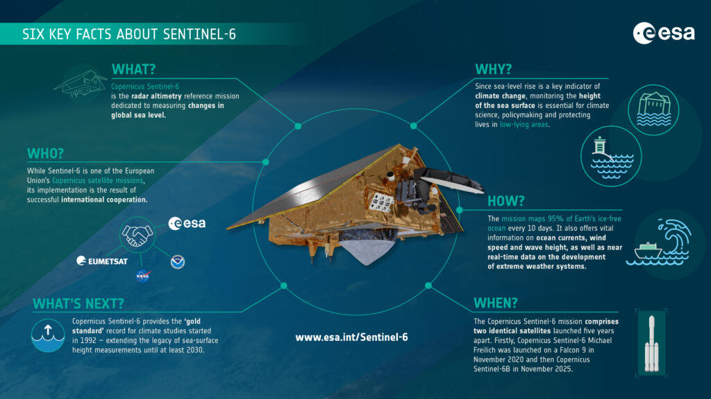
On Monday 17 November, the Sentinel-6b satellite was successfully launched aboard a SpaceX Falcon 9 rocket from the Vandenberg Space Force Base in California (USA), finally taking its place in orbit. The advanced technology integrated into the Sentinel-6b satellite will support scientists and organizations across the world to extend the unique 30-year record of sea-surface height measurements. The satellite joins its predecessor Sentinel-6 Michael Freilich, launched in 2020.
Measuring sea level change with radar altimetry
The Copernicus Sentinel-6 satellites feature advanced radar altimetry technology, which provides the most comprehensive measurements of the Ocean’s state. Combining satellite location data, radar altimeters determine sea-surface height by recording the round-trip travel time of radar pulses sent from the satellite to the Ocean surface.
Data from the Sentinel-6B mission plays a crucial role in monitoring long-term variations in sea-surface height and enhancing real-time ocean forecasts through wave-height, wind-speed and Ocean currents observations. Sea level rise is an important climate change indicator, and monitoring its evolution can drive informed climate policymaking at the European and global levels and advance a wide range of marine applications.
The Sentinel-6 mission is an integral part of the Copernicus Earth Observation component of the EU Space Programme, but relies on continued transatlantic cooperation involving the European Commission, ESA, EUMETSAT, NASA, and the US National Oceanic and Atmospheric Administration (NOOA), with support from the French Space Agency (CNES).
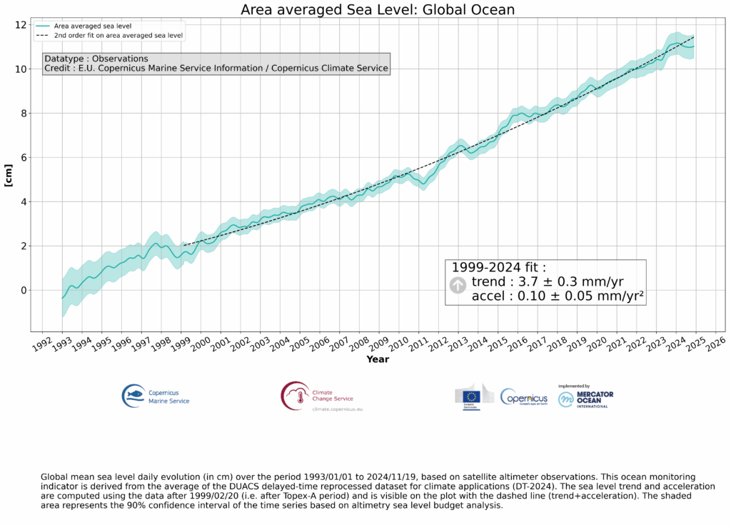
Sentinel-6b is the latest in a series of assets deployed to measure sea-level change, which began in 1992 with the French–US Topex-Poseidon satellite. Sentinel-6b is expected to operate until at least 2030 and will be joined in the next decade by Sentinel-6C, continuing the recording effort and advancing weather, ocean state and climate forecasts.
The role of Sentinel-6b within Copernicus Marine Service
Complementing data from other Sentinel missions, Sentinel-6B will ensure the continued delivery of high-quality Earth Observation data to the Copernicus Marine Service and its users. It will also directly support the advancement of Copernicus Marines’s modelling systems with more precise observations.
“Sentinel-6B has a pivotal role to advance Mercator Ocean and Copernicus Marine ocean monitoring and prediction capabilities. This satellite is not just another mission, it is a cornerstone for ocean and climate monitoring. With its very precise sea level measurements, Sentinel-6B will allow us to monitor global and regional mean sea level changes with unparalleled precision and anchor all other altimeter missions (e.g. Sentinel 3A and B), improving the way we monitor and forecast the ocean,” said Pierre-Yves Le Traon, Scientific Director of Mercator Ocean International.