Sargassum
Home ⟩ Ocean Intelligence ⟩ Ocean Bulletins & Insights ⟩ Sargassum
WHAT IS SARGASSUM ?
Sargassum is a floating brown seaweed naturally found in the Atlantic Ocean, where it provides important habitat for marine life. In recent years, however, massive blooms have spread toward coastal areas, where they accumulate on beaches, decompose, and release harmful gases. These events disrupt ecosystems and have significant impacts on local communities, tourism, and public health.
Explore more insights, data, and key information on Sargassum :
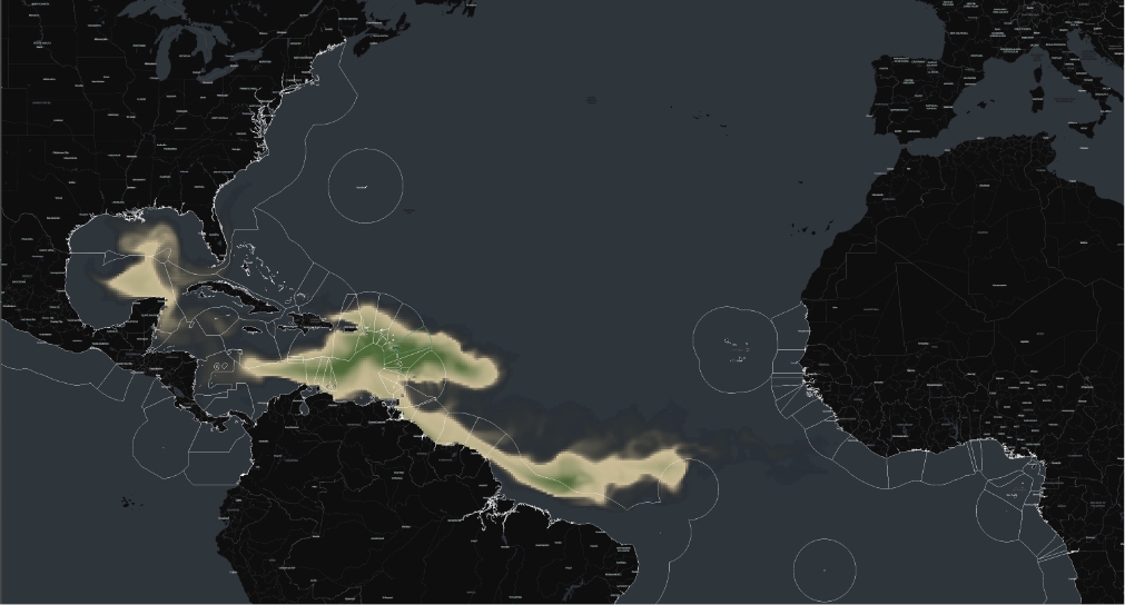
GEO Blue Planet’s impact in monitoring and forecasting Sargassum in the tropical Atlantic
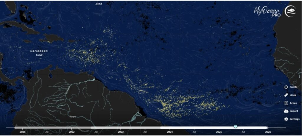
Real Time viewer on Sargassum Blooms
Hub partners provide simple online tools to monitor Sargassum and predict its movement using satellite data and models. The Copernicus Marine Service viewer (MyOcean Pro) shows recent Sargassum blooms and ocean currents, highlighting how circulation drives their transport, with some gaps due to cloud cover or satellite limits.
Key Initiatives
GEO Blue Planet Sargassum Working Group
Bringing together regional and international partners, the GEO Blue Planet Sargassum Working Group is supporting the development of monitoring and early warning systems for Sargassum across all affected regions of the Tropical Atlantic. In particular, the Sargassum Working Group focuses on identifying gaps in geo-referenced data and information that can be used for monitoring and forecasting Sargassum. Equally important, they are working to advance scientific and technical cooperation to support the implementation and development of monitoring and forecasting systems, promoting their use and the use of FAIR (Findable, Accessible, Interoperable, and Reusable) data.
One of the Working Group’s key activities is the Sargassum Information Hub. Created in collaboration with partners including the IOCARIBE of IOC-UNESCO, AtlantOS, and the Atlantic International Research (AIR) Center, the Hub acts as a centralised point for the latest information on Sargassum, Sargassum-related news and events, a project directory, and Sargassum monitoring and forecasting information, and more. The Hub will be updated with a new directory dedicated to the different actors in the Sargassum value chain.
SargCOOP2
SargCOOP2 is a project supported by GEO Blue Planet which participates in many different activities such as deploying coastal current tracking devices in nearshore waters in collaboration with Mercator Ocean International, CLS, French Space Agency CNES and CNP a subsidiary specialising in Earth Observations.
Other SARGCOOP2 activities GEO Blue Planet supports are the inclusion of a dedicated SARGCOOP Community Cluster in the Sargassum information Hub, which will act as a central repository for all of the project’s information and bring the SARG’COOP community together and provide scientific insights as and when needed.
Read more news:
Sargassum Detection: Copernicus Marine launches New Floating Algae Product | CMEMS
Copernicus Marine Service has launched a new operational Sargassum detection product, providing near real-time monitoring across the Atlantic and Caribbean. By combining multiple satellite observations, it delivers consistent, basin-scale information to track Sargassum distribution, support early warning, and improve response to coastal impacts.
Sargassum Detection: Copernicus Marine launches New Floating Algae Product | CMEMS
Sargassum Drift Tracker on the EU Digital Twin Ocean
The Sargassum Drift Tracker on the EU Digital Twin Ocean supports proactive coastal planning by providing forecasts of Sargassum distribution across the tropical Atlantic. Combining satellite data and modelling, it delivers up to 7-month outlooks and detailed insights at EEZ level, helping decision-makers anticipate blooms and manage their impacts.
Forecasts Sargassum influxes across the Equatorial Atlantic and EEZs, enabling proactive coastal and marine planning.
More projects
SCO Sesam
Since 2011, massive Sargassum blooms have impacted the Caribbean and West Africa, creating environmental, economic, and health risks. Supported by CNES’s SCO, the SeSaM project provides the first European solution integrating satellite monitoring, seasonal forecasting, and accessible visualization tools to help anticipate these events.
Dev ArcAns 36
Mercator Ocean International (MOi) improves Sargassum drift forecasts in the Caribbean by providing high-resolution subsurface currents from its regional ARCAN36 model to Météo-France. These currents force the MOTHY drift model, enabling more accurate short-term (up to 10 days) predictions of algae transport and beaching. Developed at 1/36° resolution with tidal forcing and spectral nudging toward the global GLO12 system, ARCAN36 demonstrates clear added value over lower-resolution models, as shown through validation against observations.