
Mercator Ocean International oceanographers examine marine heatwaves across the global ocean for the month of June and forecasts for the first part of July 2023. They analyse a variety of datasets from observation analyses (satellite sea surface temperature maps), to model analyses (assimilating satellite and in situ observations) and model forecasts.1
Key take-aways for the month of June 2023
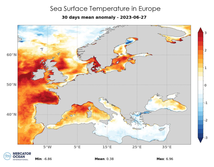
- Over the month of June, the North-East Atlantic and Mediterranean saw temperatures at least 1°C to 2°C higher than the 1993-2016 average, and the area remained in marine heatwave conditions throughout the month.
- In the last week of June, the entire Atlantic seaboard of Europe was subjected to a marine heat wave ranging from moderate intensity in the North Sea to more severe or extreme intensity in the Bay of Biscay. Compared with previous weeks, conditions were relatively more moderate near the European coasts, probably due to the weather conditions and the end of the atmospheric heat wave over the European continent.
- The western Mediterranean saw a moderate to strong heatwave at the end of June.
Forecasts up to 8 July 2023
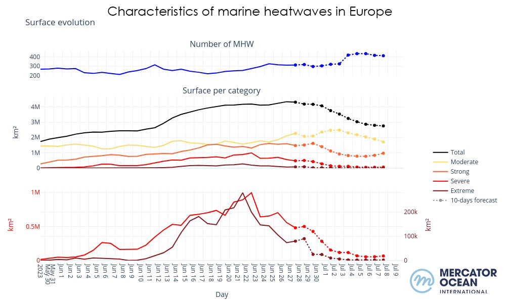
- From the beginning of July, the forecasts show a moderation of the heatwave over most of the North-East Atlantic and the Mediterranean, with a transition from the extreme category to a more moderate heatwave category. (figure 2)
- Tropical Atlantic: the models see a heatwave to the west in the Gulf of Mexico and to the east of the basin in the area off Morocco, Western Sahara and Mauritania.
- The tropical Pacific is experiencing a moderate heatwave, reaching high intensity near the coast of Peru, which is consistent with current El Nino conditions.
- A strong heatwave could appear in the Bay of Bengal
Marine heatwaves (MHW) are extreme rises in ocean temperature for an extended period of time. They can occur at different locations in the ocean, and their magnitude and frequency have increased over the last couple of decades, with harmful impacts on ecosystems, and human activities. According to the latest report released by the Intergovernmental Panel on Climate Change (IPCC AR6 SYR), it is found with high confidence that in the near-term at 1.5°C global warming, the increasing frequency of marine heatwaves will increase risks of biodiversity loss in the oceans, including from mass mortality events.[1]
[1] IPCC AR6 SYR 4.3 https://www.ipcc.ch/report/ar6/syr/downloads/report/IPCC_AR6_SYR_LongerReport.pdf