
Navigating Arctic waters poses significant challenges due to the presence of sea ice and icebergs. While forecasts for sea ice are available through the Copernicus Marine and Climate Change Services, information about icebergs is limited, only derived-satellite observations are provided in specific regions. The ACCIBERG (Arctic Cross-Copernicus forecast products for sea Ice and iceBERGs) project, led by a consortium including MOi, aims to address this gap by improving the forecasting of sea ice and providing forecasts of iceberg trajectories, thereby enhancing safety and navigation in the Arctic. The project is part of Horizon Europe; it kicked-off in February 2023 and has a duration of four years. Its next General Assembly will take place in Tromsø, Norway, on February 2nd, 2024.

Project objectives and expected outcomes
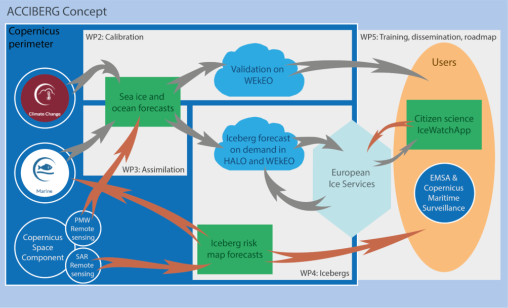
ACCIBERG aims to extend satellite detection of icebergs, developing a novel iceberg forecast service. Leveraging advanced methods in modelling, remote sensing, and cloud computing, ACCIBERG stands out for its emphasis on consistency across Copernicus data sources. The automated iceberg forecasts will benefit various users navigating the Arctic, from small fisheries to large cruise tourism, including local communities.
The project aims to deliver more reliable and accurate sea ice forecasts, accompanied by uncertainty estimates, a novel assimilation method, and user-targeted quality measures. Beyond improved safety for maritime operations, the project’s outcomes have the potential to enhance weather and ocean forecasts.
Target Users
The ACCIBERG project strategically targets a diverse range of users and stakeholders, each benefitting from the advancements in sea ice and iceberg forecasting.
- The scientific community, in particular the weather, ocean, cryosphere, climate research fields, will gain from the improvement of the ensemble approach and data assimilation techniques, enhancing their ability to study and understand Arctic environmental dynamics.
- National Ice Services, which monitor ice and provide ice information and forecasts for specific regions, will benefit from improved automated sea-ice and iceberg monitoring, ensuring more efficient and timely responses to changing conditions.
- Maritime end-users, including thosecarrying out activities in the Arctic, such as fishing/exploration/tourism/security industries as well as local communities will receive more accurate environmental information crucial for planning, tactical decision-making, and operational activities in the Arctic.
- Maritime safety organisations, specifically the European Maritime Safety Agency (EMSA), will experience an increased efficiency and safety for navigation in sea ice.
- The space sector and Earth Observation organisations (ESA, EUMETSAT, GOOS, GEO/GEOSS) can optimise satellite data utilisation for downstream applications.
- Policy makers will benefit from insights into the evolution of the European Arctic Policy and the enhancement of cross-Copernicus services.
- Additionally, ACCIBERG extends its impact to the general public by contributing to improved safety and awareness in Arctic navigation, aligning with broader societal goals.
Consortium Partners
ACCIBERG brings together a consortium of leading organisations, including:
- Mercator Ocean International,
- Stiftelsen Nansen Senter For Miljoog Fjernmaling (NERSC),
- Meteorologisk Institutt (METNO),
- European Centre For Medium-Range Weather Forecasts (ECMWF),
- Consiglio Nazionale Delle Ricerche (CNR),
- Itunova Teknoloji Anonim Sirketi (ITUNOVA), and
- Danmarks Meteorologiske Institut (DMI).
ACCIBERG General Assembly
The project’s General Assembly will take place on Friday 2nd February at the Fram Center in Tromsø, Norway, after the Arctic Frontiers conference, in a hybrid format, and will gather project’s contributors from all over Europe.