
An El Niño event has been underway since spring 2023. Conditions have been gaining strength, and as of mid-November, these are still observed in the tropical Pacific Ocean. The evolution of El Niño remains uncertain, but it is likely that it will shortly peak and end in the coming Northern Hemisphere spring. This bulletin details the latest El Niño conditions as provided by the Global Ocean Physics Reanalysis and Forecast system (GLORYS), developed at Mercator Ocean International.
Latest El Niño conditions
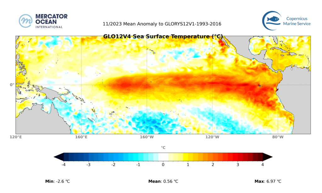
Figure 1: Sea Surface Temperature anomalies (°C) in the Pacific for November 2023. Axis are longitude and latitude. Positive (or negative) anomalies mean actual conditions are warmer (or colder) than regular conditions at the same time of the year. Analysis: GLO12 and GLORYS12. Latest update 29 November 2023
As of mid-November 2023, El Niño conditions remain strong in the Pacific Ocean.
The ocean surface is warmer than usual (for the current season) over a pattern that is centred on the equator and that extends from the central to eastern tropical Pacific region (Figure 1). This pattern is characteristic for El Niño conditions, although it can vary from event to event.
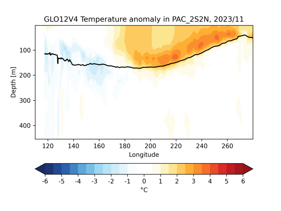
There is a pronounced warming (1-4°C) in the ocean subsurface along the equator, from the central to eastern Pacific (Figure 2).
Current subsurface warming is weaker overall than during earlier months, indicating that most ocean heat has been released. Heat tends to accumulate for a few years in the tropical Pacific subsurface, reaching the surface during El Niño events.
El Niño evolution
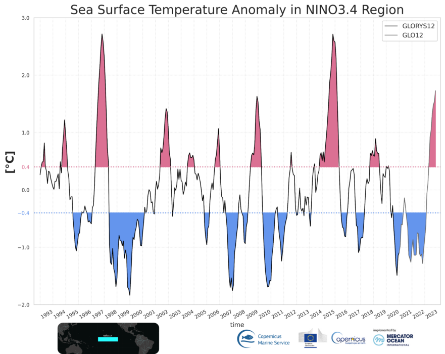
This year’s El Niño has gradually strengthened. The value Niño 3.4 sea surface temperature index is currently over +1.5°C (figure 3). To put this into historical perspective, considering current conditions, this year’s El Niño event is considered of moderate intensity, when compared to previous El Niño events. Super events can reach more than +2°C (like in 1997-98 or 2015-16). See also von Schuckamnn et al. (2016, chapt 4.1) for a detailed timeline of the super El Niño of 2015-16¹.
The future evolution of this year’s El Niño into a super event remains to be determined, as it is possible that ocean warming will increase in the coming months.
The duration of this year’s El Niño also remains to be determined, but it is likely that it will end in the coming spring with Pacific water temperatures cooling down and setting out of La Niña conditions.
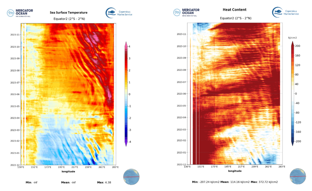
Figure 4: Left: Evolution of surface temperature anomalies (°C) along the equator in the Pacific Ocean. Axis are longitude and time. Right: Same for evolution of heat content anomalies (kg/cm², average 0-300m). Heat content is an indirect measure of subsurface temperatures. Positive (or negative) anomalies mean actual conditions are warmer (or colder) than regular conditions at the same time of the year. Data analysis: GLO12.
Following overall cooler La Niña conditions in 2022, this year’s El Niño has started with strong surface warming in the far eastern Pacific in the Northern Hemisphere spring of 2023. The warming has then gradually expanded to the central Pacific (Figure 4 – left). The event may keep developing until this year’s November/December before conditions reverse, likely around spring of 2024.
As a general mechanism, heat that piles up in the subsurface of the tropical Pacific works as a starting engine and fuel for the development of El Niño conditions. Strong ocean warming was already present in the subsurface as early as late 2022 (Figure 4 – right). The heat remained confined to the western Pacific in 2022, before gradually expanding eastwards during the spring of 2023, and reaching surface layers. As of now, subsurface warming extends from the central to eastern Pacific and it seems to be weakening overall, which may hinder further development of the event.
The development of this year’s El Niño remains to be confirmed, but it is likely that it will end in the spring of 2024 with Pacific Ocean temperatures cooling down and setting up distinctive La Niña conditions.
What is El Niño?
El Niño is a natural and recurring climate event emerging every 2 to 4 years in the tropical Pacific Ocean. It has a global reach, and its intensity and impacts vary widely from one event to another. The event can affect weather patterns, ecosystems, and populations quite dramatically.
Ocean warming from El Niño can be very strong. It can affect marine life, and increase fish mortality, affecting the economic sector and coastal populations for an entire season in certain areas of the globe. The stored heat is transferred to the atmosphere that modifies winds and precipitation patterns, and can originate either flooding or drought, depending on the region.
The specific impacts of this year’s El Niño and its future evolution remain to be detailed and are not discussed in this bulletin.
Methods and datasets
The present bulletin details the latest El Niño conditions as provided by the Global Ocean Physics Reanalysis System (GLORYS12)² developed at Mercator Ocean International (MOi). The system blends available observations with ocean physics present in numerical models, such as GLO12, to provide highly detailed monitoring of the state of the ocean at high resolution (1/12°) and with global coverage.
- GLORYS12 – global ocean eddy-resolving (1/12° horizontal resolution, 50 vertical levels) reanalysis covering the altimetry era (1993 onwards), developed by MOi and disseminated by the Copernicus Marine Service.
- GLO12 – 3D ocean model analysis and forecast developed by MOi and disseminated by the Copernicus Marine Service.
Contributions for this bulletin from:
Sulian Thual, Eric Pellereau, Charly Regnier
References
¹Von Schuckmann, K., Le Traon, P.Y., Alvarez-Fanjul, E., Axell, L., Balmaseda, M., Breivik, L.A., Brewin, R.J., Bricaud, C., Drevillon, M., Drillet, Y. and Dubois, C., 2016. The copernicus marine environment monitoring service ocean state report. Journal of Operational Oceanography, 9(sup2), pp.s235-s320.
²Lellouche, J.M., Le Galloudec, O., Greiner, E., Garric, G., Regnier, C., Drevillon, M., Bourdallé-Badie, R., Bricaud, C., Drillet, Y. and Le Traon, P.Y., 2018, April. The Copernicus Marine Environment Monitoring Service global ocean 1/12 physical reanalysis GLORYS12V1: description and quality assessment. In EGU General Assembly Conference Abstracts (Vol. 20, p. 19806).